March 14 – 23, 2013
Arizona, Nevada, California, Utah:
Phoenix to Parker to Death Valley to Lee's Ferry
Note to reader: Try double-clicking on an image and it should expand into a full-size image, and possibly a slideshow.
Thursday, March 14, 2013
 Left EARLY from Durango (7:45 am) to head to Phoenix to pick up the trailer, drag it around and bring it on home. The weather in Durango has been sunny now after the last snow a week ago, and could be as warm as 60 by tomorrow. For a change this time we took 160 on thru Kayenta (no dogs!) and Tuba City. We stopped in Flagstaff at Thunderbird jewelry supply, sister store to the big one in Gallup, and lunch at Subway and off we went again. I wanted a McD shamrock shake, but the Micky D's in Flagstaff said they were "all out" --- what??? This is the first time in a year I want a shake and I couldn't have it? Now it will be my mission... On we drove south, leaving the pleasant 60s then 70s behind, only to find 97 in Phoenix traffic. wow dats hot. Let-down of the day: my driver also refused to take me into downtown Phoenix so I could yell "HI NANCY GRACE!" out the window during a drive-by of the Jodi Arias Trail. So close, and yet so far away. Right near the RV storage is a Mc Donalds; we hit the drive-thru. We order. We are told the milkshake machine is down. WTF????? really?! Tomorrow is another day for a milkshake. We unloaded, changed clothes to cool off, and hit the shops to kill time; we would be spending the night in the casino parking lot with no electric and no a/c, so best to stay out until dark. And we did. First, Hobby Lobby, dinner at Thai Basil Signature (very good) on Chandler, then, of course and naturally, Trader Joe's. Now we can resume life in the trailer. We were both exhausted so we were asleep before we noticed we were camped in a parking lot at the Lone Butte Casino.
Friday, March 15, 2013
 |
| That's us, dead center, circled in red. |
Today will be record heat -- how DO we time things so well, I have no idea. But we are moving on, west to the final destination of Parker, home of a dam and the Colorado River, and lots and lots of retirees and vacation homes. Kind of overcast today but the warmest I saw was 93 in Parker. Which is also where I finally got a Shamrock Shake (it wasn't all that). We will be staying two nights at River Island State Park sorta on the river, which is like a narrower Intracoastal, even with a few loud, fast boats. I should mention we drove past Quartzite on the way here, but my driver would not cruise the town which had books and rocks as a promise. Nope no sir no way, we have to get to Parker. And when we did we wondered why... Not much to do except play on the river, not my idea of fun. We walked down to see the water but it was very hot out so we went staight back to the hot dog and cranked up the a/c then drove back to Parker to make sure we didn't miss anything. We didn't. But we did discover Riverside Drive, that was nice. Lots of second homes I think, and bars. 20 years ago this might have been promising to my interests, but now, not so much. (What? no yarn or bead shops???) We did get to the tourist center to learn about two interesting things: The Nellie E. Saloon five miles out in the desert (tomorrow) only open on weekends, and the ghost town of Swansea, also on the list for tomorrow.
 |
| Parker Dam. And you can drive over this one. |
Saturday, March 16, 2013
 |
| That's California on the other side of the Colorado River. |
Exploration day, but first, a hike up to the top of the hill at the campsite to get the 180 view of the area, pretty neat and the beaver-tail prickly pear cacti were blooming. We then drove 11 miles south to Parker to head east and into the desert to visit the ghost townsite of Swansea, an old copper mine which went out of business in the early 1900s. Next we went to the (in)famous Desert Bar, built about 30 years ago about 5 miles out in the desert east of Parker. Some guy acquired old mining land and slowly built a bar that is only open on weekends, noon to sundown. Very popular, and as expected, probably more famous for it's T shirts. Nothing great, just a very unusual setting. Lots of retirees, a so-so band and oddly enough, helicopter rides. The dirt road was windy, and more challenging than the drive to Swansea. And these people were driving out under the influence. Probably why it's not open after dark.
 |
| See the Parker Dam off in the distance? |
 |
| The beaver tail prickly pear are in bloom. |
 |
| The Arizona Canal. |
 |
| A blast from the past in Parker. |
 |
| A ghost in the ghost town of Swansea, where copper was king. |
 |
| The rules don't apply to Billy... |
 |
| Swansea Ruins |
 |
| Approach to the Desert Bar, Nellie E. That's a fake church they built. |
 |
| Just a strange, rambling establishment. Nothing else to do I guess. |
 |
| But they do have helicopter rides. (Looks like the last scene from MASH.) No, we didn't go. |
Sunday, March 17, 2013
 |
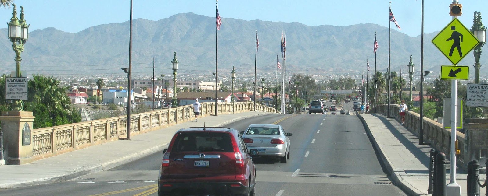
| London Bridge in Lake Havasu, AZ |
At Parker we were in spot #13 at the River Island State Park, center of the little park. Water and electric, $55 for two nights. Don't know where we are heading, depends on weather -- it's warming up already. About 90 in Parker. Today we moved on north to drive through Lake Havasu City and drive over the London Bridge, then on to Oatman, home of the roaming burros. Oatman was a little (junky) old former mining town and now a tourist trap thanks to the burros. Didn't stay long, almost couldn't find a place to park the rig but lucked out, with me standing in two parking spots chasing off cars while Bill fetched the truck. The cool part was driving an old winding part of Route 66 to get there. That was pretty cool. Final destination was Lake Mead
 |
| Route 66 through Arizona on the way to Oatman. |
and Boulder Beach to stay at the cramped full hookup side. Probably won't do that again, not much ambiance... It was a long day and we were so pooped so we didn't even take it off the truck as we knew we would be busting out early in the am.

 |
| This baby was so soft! Spinable I'd say. |
 |
| And the mules own the town, so get out of their way. |
 |
| Sunset on Lake Mead at Boulder Beach campground. |
Monday, March 18, 2013
 |
| Furnace Creek Campground. And the lack of shade near our site. |
Heading to Death Valley now, with a grocery stop in Pahrump. What a weird city name. The mountains west of Las Vegas are pretty nice, especially when you see the temps drop 10 degrees. Drove all the way to Death Valley, looking around in awe of the fact that we were soon to be 214 feet below seal level at, of all things, the golf course. It was plenty warm, so after securing a spot at Furnace Creek Campground we thought it best to drive around and see the sights (with the a/c blasting) for the remainder of the day. Campground was pretty full with families for spring break so not exactly peaceful. Saw Zabriskie Point, Artist Drive, and the little post office a few times. How convenient was that. Fortunately the night cooled off enough for comfort without a/c and we were asleep before long, after another long day of driving around.
 |
| Japanese tourists in M&M shirts at Zabriskie Point |
 |
| At Furnace Creek |
 |
| Zabriskie Point |
 |
| Zabriskie Point Overlook |
 |
| Artist Drive |
 |
| Artist's Palette |
Tuesday, March 19, 2013
Cool morning here at 200 feet below at Furnace Creek (66 degrees) so we walked over to the visitor center and village to check it out some more, like the old wagons behind the borax museum. Then we drove over to the Furnace Creek Inn for a lobby tour -- it was way nicer than expected, as we, the riffraff, blew through. Rooms are anywhere from $275 - $450. We've decided to leave this busy and hot with no shade campground for Stovepipe Wells so we packed up and moved on. One look at Stovepipe 20 miles up the road and we kept on going--it was basically a parking lot on gravel with parking bumpers! And not an inch of shade. Again, it's a high of 90 but without shade, it is a killer. Taking our chances on availability we headed on north to the last in the series: Mesquite Springs. Lucked out! A few low bushes but located along a wash and way more scenic than the previous, with hiking over the wash as well. We are a bit higher so we have a nice cool breeze tho it is 83 or so -- still hot in the direct sun. Later in the afternoon we drove three miles to Scotty's Castle, very interesting, another example of what the wealthy did with their dough in the 1920s. Interesting tour of an eccentric's home. And an interesting personal story of Johnson: http://en.wikipedia.org/wiki/Albert_Mussey_Johnson
Came back climbed up the slope of rocks across the wash to rock nirvana -- a plateau of rock of all shapes and sizes, so soon Bill left me to myself and my rocks. Glorious. Tonight we shall cook out and enjoy some cooler temps. I think we are above seal level now. The stars were amazing, this is where the dark skies are.
 |
| 20-Mule Team Borax Wagon at Furnace Creek |
 |
| Furnace Creek Inn exterior and Lobby Tour. (Hey, what am I doing in a trailer?? |
 |
| Furnace Creek fuel prices -- you don't want to fill up down here. |
 |
| Golf course at Furnace Creek. 214 feet below sea level. Just imagine how nice it would be in August. |
 |
| Mesquite Campground. Tricky pic; looks like we are alone but we're not. Just a lucky shot. |
 |
| Scotty's Castle. That cross up on the hill in the background is Scotty's grave. |
 |
| In the courtyard of "Scotty's Castle"; it's really called Death Valley Ranch. |
 |
| What a place this was -- and still is, just as they left it. |
Wednesday, March 20, 2013 - Spring, almost! and our coolest morning here to date...
Decided to stay another night here so today we took a drive thru Scotty's Junction and over to Beatty to get gas. Vast open emptiness, and a single truck rollover sorta near the Shady Lady Ranch location, a Nevada brothel in the middle of nowhere. We drove back to camp the long winding way through Titus Canyon which had two ghost towns to tour: Rhyolite and Leadfield. Rhyolite was the larger of the two but not real exciting. Concrete building remains from the 1920s, and the Bottle House, a small house a man created for a raffle, the brochure said, but it also served as someone's home. I think I saw this featured on TV long ago.
Out in the yard was a mosaic village of little buildings, rough to say the least. I'm ready to lend a hand if needed. We also toured the little cemetery down the road to say hi to everyone.

A monument erected in the late 1950s looks like the last time anyone paid this place any attention. The 27-mile drive through Titus Canyon was really nice, beautiful, colorful mountains, maybe 4000+ in elevation, the winding road looped through the mountain range on the east side of the park, taking you through a high walled canyon until it lets out back in Death Valley. Bill eyed some big lizards off to the side but other than that not much life, not even birds around here. Our last site of the day was Ubehebe Crater, three miles north of our camp. That was a big surprise like the beauty of Titus Canyon -- was expecting a dent on the earth's surface, but instead it was a huge and colorful crater! and windy! and crowded. Didn't stay long; was entertained by a raven soaring on the wind currents but the wind was just too much, so a few photos and off we went. Back at camp I raced back up for another walk on the moon -- back up my mountain on the other side of the wash. Love it up there, rocks and rocks and rocks... and a snake. Suddenly I see wavy back end of a tan and black snake, half under a rock after coming within about two feet of it. Well that did it for my rock hunting -- my eyes were now focused on black and tan wavy things. ewww!!! Don't consider myself afraid of snakes, but that one surprised m, as earlier I wondered, hmm, what if I get bit by a snake up here by myself and have to drag the leg back to the edge to get down... and how long would I wait before Bill would come look for my lifeless body among this lunar surface.... so ended my journey. Time to head down. Note: Looked up the snake: Horned Death they call it! A Sidewinder Rattlesnake! Darn, didn't see the horned head and didn't have a camera anyway, and don't remember a rattle but then I didn't hang around long to examine it…but this is what I saw. http://www.desertusa.com/mag98/april/papr/du_sidewind.html
 |
| Titus Canyon Drive |
 |
| I know what this was! Wandering thru yet another ghost town, Leadfield. |
|
 |
| A Chuckwalla in Titus Canyon. Good eye, Bill -- he spotted this big fat thing from the car. |
 |
| Ubehebe Crater is half a mile (one kilometer) wide and 500 to 777 feet (150
to 237 m) deep. The age of the crater is estimated from 2,000 to 7,000
years old.[1] "Ubehebe" (pronounced YOO-bee-HEE-bee) is a Timbisha Native American word meaning "Big basket in the rock." |
 |
| Bill on the brink. It was SO windy there ravens hovered. It was nice but we didn't stay long. |
Thursday, March 21, 2013
 |
| Another beautiful day in Utah. That sky is for real. |
Left Death Valley, with plans to return next time in February, when it's a tad cooler. Bill has noticed a rear trailer tire wearing on the edge so we drove to Las Vegas' Discount Tire for a rotation. Good timing - I have an ad to work on. Bright sunny day but windy as all get out as that system seems to be moving through but leaving us with the sun down here. We continued on to just west of St. George Utah and spent the night at a campground off I-15 in the Virgin River Canyon, beautiful area. Just a quick stay, left the trailer on the truck for a quick getaway tomorrow. Still listening to the Arias trial. Bill not so thrilled with my addiction but with Sirrius radio and Headline News, I can't help myself.
Friday, March 22, 2013
 |
| That dark area is the Colorado River. |
Took some time to walk down to the river before departure. Lots of rocks! But none suitable for a birdbath. They are all safe where they are. We left the interstate and headed toward Fredonia with no real plan, but would end up at Lees Ferry for the night. While shopping at Prairie Dog Pottery in Fredonia the potter told us the highway was out south of Page, so we planned accordingly. Boy he was right: Apparently on Feb. 20 there was a total geologic collapse which destroyed a large section of the road. Small World Alert: These Fredonia potters have a son living in Wilton Manors, Florida. Still super windy on our drive eastward, which took us a bit higher into pine trees near Jacob Lake. Good to see those again, since we've been deserting all week. Got a nice spot at Lees Ferry and took off to see the historic Lonely Dell Ranch site in the park. http://en.wikipedia.org/wiki/Lee%27s_Ferry_and_Lonely_Dell_Ranch


The period of significance for the district extends from the 1871 arrival of the Lees to the last run of the ferry in 1928, according to wiki. Fortunately the trailer was set up with the back end to the winds, which got stronger as the day went on. Had to hold on to that door or it would rip it off! I can't imagine how the tenters kept them standing through the night. It was bad. But we're moving on in the am because it's going to get colder. At least we had a signal here in the park so we could use our phones and computer.
 |
| Navajo Bridge |
Saturday, March 23, 2013
Going home day. Hit the road by 9:30 (how we manage to hit this exact departure time so often I don't know. 9:30 is the magic time) and drove all the way home, arriving about 4:30 or so. Sunny but cold day everywhere, which is why we went all the way home. Barely broke 30 degrees, arriving to 25 in Durango. I did manage to visit three trading posts on the way, including Teec Nos Pos, but didn't find anything I couldn't live without, amazingly (I usually do). So now the armored hot dog is home safe and sound; no more trips to Phoenix for a while.
 |
| A stop on the Reservation on the way home. |

 Left EARLY from Durango (7:45 am) to head to Phoenix to pick up the trailer, drag it around and bring it on home. The weather in Durango has been sunny now after the last snow a week ago, and could be as warm as 60 by tomorrow. For a change this time we took 160 on thru Kayenta (no dogs!) and Tuba City. We stopped in Flagstaff at Thunderbird jewelry supply, sister store to the big one in Gallup, and lunch at Subway and off we went again. I wanted a McD shamrock shake, but the Micky D's in Flagstaff said they were "all out" --- what??? This is the first time in a year I want a shake and I couldn't have it? Now it will be my mission... On we drove south, leaving the pleasant 60s then 70s behind, only to find 97 in Phoenix traffic. wow dats hot. Let-down of the day: my driver also refused to take me into downtown Phoenix so I could yell "HI NANCY GRACE!" out the window during a drive-by of the Jodi Arias Trail. So close, and yet so far away. Right near the RV storage is a Mc Donalds; we hit the drive-thru. We order. We are told the milkshake machine is down. WTF????? really?! Tomorrow is another day for a milkshake. We unloaded, changed clothes to cool off, and hit the shops to kill time; we would be spending the night in the casino parking lot with no electric and no a/c, so best to stay out until dark. And we did. First, Hobby Lobby, dinner at Thai Basil Signature (very good) on Chandler, then, of course and naturally, Trader Joe's. Now we can resume life in the trailer. We were both exhausted so we were asleep before we noticed we were camped in a parking lot at the Lone Butte Casino.


 Thursday, March 21, 2013